Thursday, February 26, 2015

Santorini, Greece

Santorini is an island in the southern Aegean Sea, about 200 km (120 mi) southeast of Greece's mainland. It is the largest island of a small, circular archipelago which bears the same name and is the remnant of a volcanic caldera.


Santorini is essentially what remains after an enormous volcanic eruption that destroyed the earliest settlements on a formerly single island, and created the current geological caldera. A giant central, rectangular lagoon, which measures about 12 by 7 km (7.5 by 4.3 mi), is surrounded by 300 m (980 ft) high, steep cliffs on three sides. 


The main island slopes downward to the Aegean Sea. On the fourth side, the lagoon is separated from the sea by another much smaller island called Therasia; the lagoon is connected to the sea in two places, in the northwest and southwest. The depth of the caldera, at 400m, makes it possible for all but the largest ships to anchor anywhere in the protected bay.


The capital, Fira, clings to the top of the cliff looking down on the lagoon.Fira is a city of white-washed houses built on the edge of the 400 metres high caldera on the western edge of the semi-circular island of Thera. The two main museums of interest are the Archaeological Museum of Thera, 30 metres (98 feet) east of the cable car entrance, and the Museum of Prehistoric Thera at the southeast corner of the White Orthodox Cathedral of Ypapanti, built on the site of an earlier church destroyed in the 1956 earthquake.


Access to Fira is mainly by roads on its eastern side, climbing from its port via the Z-shaped footpath on foot or on donkeys, or by riding the steep cable car from its lower terminal by the port. The central square of Fira is called Plateia Theotokopoulou, with a bus and taxi station, banks and pharmacies. From Fira there is a panoramic view of the 18 kilometres (11 miles) long caldera from southern Cape Akrotiri to northern Cape Ag. Nikolaos, plus the volcanic island Nea Kameni at the center with Thirassia Island in the Aegean.


Santorini was named by the Latin Empire in the thirteenth century, and is a reference to Saint Irene, from the name of the old cathedral in the village of Perissa - the name Santorini is a contraction of the name Santa Irini. Before then, it was known as Kallístē or Thēra. The name Thera was revived in the nineteenth century as the official name of the island and its main city, but the colloquial name Santorini is still in popular use. During the Ottoman Empire's domination of the Aegean Sea, the Turkish exonym for the island was "Santurin" or "Santoron".


Santorini and Anafi are the only locations in Europe to feature a hot desert climate according to the Köppen climate classification system.Santorini generally experiences two seasons. April to October is the warm and dry season and the cold and rainy season lasts from November to March.Total rainfall averages about 15 inches per year.


The expansion of tourism has resulted in the growth of the economy and population. The major settlements include Fira (Phira), Oia, Emporio, Kamari, Perissa, Imerovigli, Pyrgos, and Therasia. Akrotiri is a major archaeological site, with ruins from the Minoan era. Santorini's primary industry is tourism, particularly in the summer months. In 2007, the cruise ship MS Sea Diamond ran aground and sank inside the caldera. The island's pumice quarries have been closed since 1986, in order to preserve the caldera. Santorini was ranked the world's top island for many other magazines and travel sites, including the Travel+Leisure Magazine, the BBC, as well as the US News.

Sunday, February 22, 2015

Venice, Italy

Venice is a city in northeastern Italy sited on a group of 117 small islands separated by canals and linked by bridges. It is located in the marshy Venetian Lagoon which stretches along the shoreline, between the mouths of the Po and the Piave Rivers. Venice is renowned for the beauty of its setting, its architecture, and its artworks. The city in its entirety is listed as a World Heritage Site, along with its lagoon.


Venice is the capital of the Veneto region. In 2009, there were 270,098 people residing in Venice's comune (the population estimate of 272,000 inhabitants includes the population of the whole Comune of Venezia; around 60,000] in the historic city of Venice (Centro storico); 176,000 in Terraferma (the Mainland), mostly in the large frazioni (roughly equivalent to "parishes" or "wards" in other countries) of Mestre and Marghera; 31,000 live on other islands in the lagoon).


The name is derived from the ancient Veneti people who inhabited the region by the 10th century BC. The city historically was the capital of the Republic of Venice. Venice has been known as the "La Dominante", "Serenissima", "Queen of the Adriatic", "City of Water", "City of Masks", "City of Bridges", "The Floating City", and "City of Canals". Luigi Barzini described it in The New York Times as "undoubtedly the most beautiful city built by man".Venice has also been described by the Times Online as being one of Europe's most romantic cities.


According to the Köppen climate classification, Venice has a Humid subtropical climate (Cfa), with cool winters and very warm summers. The 24-hour average in January is 3.3 °C (37.9 °F), and for July this figure is 23.0 °C (73.4 °F). Rain and snow is spread relatively evenly throughout the year, and averages 748 millimetres (29.4 in).


Venice is one of the most important tourist destinations in the world for its celebrated art and architecture. The city has an average of 50,000 tourists a day (2007 estimate). In 2006, it was the world's 28th most internationally visited city, with 2.927 million international arrivals that year.


Today, there are numerous attractions in Venice, such as St Mark's Basilica, the Grand Canal, and the Piazza San Marco. The Lido di Venezia is also a popular international luxury destination, attracting thousands of actors, critics, celebrities, and mainly people in the cinematic industry. The city also relies heavily on the cruise business. The Cruise Venice Committee has estimated that cruise ship passengers spend more than 150 million euros (US $193 million) annually in the city.


Venice is built on an archipelago of 117 islands formed by 177 canals in a shallow lagoon, connected by 409 bridges. In the old centre, the canals serve the function of roads, and almost every form of transport is on water or on foot. In the 19th century, a causeway to the mainland brought the Venezia Santa Lucia railway station to Venice, and the Ponte della Libertà road causeway and parking facilities (in Tronchetto island and in piazzale Roma) were built during the 20th century. 


Beyond the road and rail land entrances at the northern edge of the city, transportation within the city remains (as it was in centuries past) entirely on water or on foot. Venice is Europe's largest urban car-free area. Venice is unique in Europe, in having remained a sizable functioning city in the 21st century entirely without motorcars or trucks.


The maze of canals threaded through the city requires the use of more than 400 bridges to permit the flow of foot traffic. In 2011, the city opened Ponte della Costituzione, the fourth bridge across the Grand Canal, connecting the Piazzale Roma bus terminal area with the Stazione Ferroviaria (train station), the others being the original Ponte di Rialto, the Ponte dell'Accademia, and the Ponte degli Scalzi. 


The main public transportation means are motorised waterbuses (vaporetti) which ply regular routes along the Grand Canal and between the city's islands. The only gondole still in common use by Venetians are the traghetti, foot passenger ferries crossing the Grand Canal at certain points without bridges.


Thursday, February 19, 2015

Pamukkale, Turkey

Pamukkale, meaning "cotton castle" in Turkish, is a natural site in Denizli Province in southwestern Turkey. 


The site contains hot springs and travertines, terraces of carbonate minerals left by the flowing water. It is located in Turkey's Inner Aegean region, in the River Menderes valley, which has a temperate climate for most of the year.


The ancient Greco-Roman and Byzantine city of Hierapolis was built on top of the white "castle" which is in total about 2,700 metres (8,860 ft) long, 600 m (1,970 ft) wide and 160 m (525 ft) high, many ruins of ancient Roman buildings can be seen there such as a theatre that could hold up to 10.000 people.

Tourism is and has been a major industry. People have bathed in its pools for thousands of years. As recently as the mid-20th century, hotels were built over the ruins of Hierapolis, causing considerable damage. An approach road was built from the valley over the terraces, and motor bikes were allowed to go up and down the slopes.


 When the area was declared a World Heritage Site, the hotels were demolished and the road removed and replaced with artificial pools. Wearing shoes in the water is prohibited to protect the deposits.


Pamukkale's terraces are made of travertine, a sedimentary rock deposited by water from the hot springs. In this area, there are 17 hot water springs in which the temperature ranges from 35 °C (95 °F) to 100 °C (212 °F).


The water that emerges from the spring is transported 320 metres (1,050 ft) to the head of the travertine terraces and deposits calcium carbonate on a section 60 to 70 metres (200 to 230 ft) long covering an expanse of 24 metres (79 ft) to 30 metres (98 ft). 


When the water, supersaturated with calcium carbonate, reaches the surface, carbon dioxide de-gasses from it, and calcium carbonate is deposited. The depositing continues until the carbon dioxide in the water balances the carbon dioxide in the air. Calcium carbonate is deposited by the water as a soft jelly, but this eventually hardens into travertine.


Sunday, February 15, 2015

Petra, Jordan

Petra or Al-Batra inArabic is a historical and archaeological city in the southern Jordanian governorate of Ma'an that is famous for its rock-cut architecture and water conduit system. Another name for Petra is the Rose City due to the color of the stone out of which it is carved.


Established possibly as early as 312 BC as the capital city of the Nabataeans, it is a symbol of Jordan, as well as Jordan's most-visited tourist attraction.It lies on the slope of Jebel al-Madhbah (identified by some as the biblical Mount Hor) in a basin among the mountains which form the eastern flank of Arabah (Wadi Araba), the large valley running from the Dead Sea to the Gulf of Aqaba. Petra has been a UNESCO World Heritage Site since 1985.


The site remained unknown to the Western world until 1812, when it was introduced by Swiss explorer Johann Ludwig Burckhardt. It was described as "a rose-red city half as old as time" in a Newdigate Prize-winning poem by John William Burgon. UNESCO has described it as "one of the most precious cultural properties of man's cultural heritage"


Pliny the Elder and other writers identify Petra as the capital of the Nabataeans and the center of their caravan trade. Enclosed by towering rocks and watered by a perennial stream, Petra not only possessed the advantages of a fortress, but controlled the main commercial routes which passed through it to Gaza in the west, to Bosra and Damascus in the north, to Aqaba and Leuce Come on the Red Sea, and across the desert to the Persian Gulf.


Excavations have demonstrated that it was the ability of the Nabataeans to control the water supply that led to the rise of the desert city, creating an artificial oasis. The area is visited by flash floods and archaeological evidence demonstrates the Nabataeans controlled these floods by the use of dams, cisterns and water conduits. These innovations stored water for prolonged periods of drought, and enabled the city to prosper from its sale.


Today, most modern visitors approach the site from the east. The impressive eastern entrance leads steeply down through a dark, narrow gorge (in places only 3–4 m (9.8–13.1 ft) wide) called the Siq ("the shaft"), a natural geological feature formed from a deep split in the sandstone rocks and serving as a waterway flowing into Wadi Musa.


At the end of the narrow gorge stands Petra's most elaborate ruin, Al Khazneh (popularly known as and meaning "the Treasury"), hewn into the sandstone cliff. While remaining in remarkably preserved condition, the face of the structure is marked by hundreds of bullet holes made by the local Bedouin tribes that hoped to dislodge riches that were once rumored to be hidden within it.


A little farther from the Treasury, at the foot of the mountain called en-Nejr, is a massive theatre, positioned so as to bring the greatest number of tombs within view. At the point where the valley opens out into the plain, the site of the city is revealed with striking effect. The amphitheatre has been cut into the hillside and into several of the tombs during its construction. Rectangular gaps in the seating are still visible. Almost enclosing it on three sides are rose-colored mountain walls, divided into groups by deep fissures and lined with knobs cut.


Byzantine era – decline
Petra declined rapidly under Roman rule, in large part from the revision of sea-based trade routes. In 363 an earthquake destroyed many buildings, and crippled the vital water management system. The last inhabitants abandoned the city (further weakened by another major earthquake in 551) when the Arabs conquered the region in 663. The ruins of Petra were an object of curiosity in the Middle Ages and were visited by Sultan Baibars of Egypt towards the end of the 13th century. The first European to describe them was Swiss traveller Johann Ludwig Burckhardt in 1812.


Wednesday, February 11, 2015

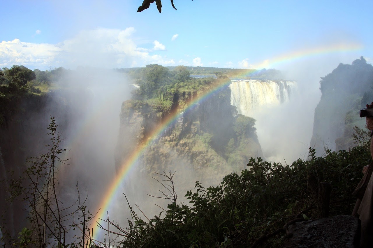
Victoria Falls

Victoria Falls, or Mosi-oa-Tunya is a waterfall in southern Africa on the Zambezi River at the border of Zambia and Zimbabwe.


David Livingstone, the Scottish missionary and explorer, is believed to have been the first European to view Victoria Falls on 16 November 1855 from what is now known as Livingstone Island, one of two land masses in the middle of the river.


Livingstone named his discovery in honour of Queen Victoria, but the indigenous name, Mosi-oa-Tunya—"the smoke that thunders"—continues in common usage as well. The nearby national park in Zambia, for example, is named Mosi-oa-Tunya, whereas the national park and town on the Zimbabwean shore are both named Victoria Falls.The World Heritage List officially recognizes both names.


In 2013 the government of Zimbabwe declared its intention to officially rename the falls "Mosi-oa-Tunya", citing continuity with other renamings such as Harare (from Salisbury), and Zimbabwe (from Rhodesia).


While it is neither the highest nor the widest waterfall in the world, it is classified as the largest, based on its width of 1,708 metres (5,604 ft) and height of 108 metres (354 ft), resulting in the world's largest sheet of falling water. Victoria Falls is roughly twice the height of North America's Niagara Falls and well over twice the width of its Horseshoe Falls. In height and width Victoria Falls is rivalled only by Argentina and Brazil's Iguazu Falls.


European settlement of the Victoria Falls area started around 1900 in response to the desire of Cecil Rhodes' British South Africa Company for mineral rights and imperial rule north of the Zambezi, and the exploitation of other natural resources such as timber forests north-east of the falls, and ivory and animal skins.


By the end of the 1990s almost 300,000 people were visiting the falls annually, and this was expected to rise to over a million in the next decade. Unlike the game parks, Victoria Falls has more Zimbabwean and Zambian visitors than international tourists; the attraction is accessible by bus and train, and is therefore comparatively inexpensive to reach.


The two countries permit tourists to make day trips from each side and visas can be obtained at both border posts. Costs vary from US$45-US$80 (as of 1 December 2013). Visitors with single entry visas are required to purchase a visa each time they cross the border. Frequent changes in visa regulations mean visitors should check the rules before crossing the border.


A famous feature is the naturally formed "Armchair" (now sometimes called "Devil's Pool"), near the edge of the falls on Livingstone Island on the Zambian side. When the river flow is at a certain level, usually between September and December, a rock barrier forms an eddy with minimal current, allowing adventurous swimmers to splash around in relative safety a few feet from the point where the water cascades over the falls. Occasional deaths have been reported when people have slipped over the rock barrier.

Sunday, February 8, 2015

Machu Picchu in Peru


Machu Picchu is a 15th-century Inca site located 2,430 metres (7,970 ft) above sea level. It is located in the Cusco Region, Urubamba Province, Machupicchu District in Peru. It is situated on a mountain ridge above the Sacred Valley which is 80 kilometres (50 mi) northwest of Cusco and through which the Urubamba River flows. 


Most archaeologists believe that Machu Picchu was built as an estate for the Inca emperor Pachacuti (1438–1472). Often mistakenly referred to as the "Lost City of the Incas", it is the most familiar icon of Inca civilization.


The Incas built the estate around 1450, but abandoned it a century later at the time of the Spanish Conquest. Although known locally, it was unknown to the outside world before being brought to international attention in 1911 by the American historian Hiram Bingham. Since then, Machu Picchu has become the largest tourist attraction in South America. 


Most of the outlying buildings have been reconstructed in order to give tourists a better idea of what the structures originally looked like. By 1976, thirty percent of Machu Picchu had been restored. The restoration work continues to this day.


Since the site was not known to the Spanish during the colonial period, it is highly significant as a relatively intact cultural site. Machu Picchu was declared a Peruvian Historical Sanctuary in 1981 and a UNESCO World Heritage Site in 1983. In 2007, Machu Picchu was voted one of the New Seven Wonders of the World in a worldwide Internet poll.


Machu Picchu was built in the classical Inca style, with polished dry-stone walls. Its three primary structures are the Inti Watana, the Temple of the Sun, and the Room of the Three Windows. These are located in what is known by archaeologists as the Sacred District of Machu Picchu.


Machu Picchu is vulnerable to threats. While natural phenomena like earthquakes and weather systems can play havoc with access, the site also suffers from the pressures of too many tourists. In addition, preservation of the area's cultural and archaeological heritage is an ongoing concern.


Thursday, February 5, 2015

Iguazu Falls

Iguazu Falls are waterfalls of the Iguazu River on the border of the Argentina province of Misiones and the Brazilian state of Paraná.


The falls divide the river into the upper and lower Iguazu. The Iguazu River rises near the city of Curitiba. For most of its course, the river flows through Brazil, however, most of the falls are on the Argentine side. Below its confluence with the San Antonio River, the Iguazu River forms the boundary between Argentina and Brazil.


Distribution of the falls between Argentina and Brazil

The Iguazu Falls are arranged in a way that resembles a reversed letter "J". The border between Brazil and Argentina runs through the Devil's Throat. On the right bank is the Brazilian territory, which has just over 20% of the jumps of these falls, and the left side jumps are Argentine, which make up almost 80% of the falls.


The falls may be reached from two main towns, with one on either side of the falls: Puerto Iguazú in Argentina and Foz do Iguaçu in Brazil, as well as from Ciudad del Este, Paraguay, on the other side of the Paraná river from Foz do Iguaçu. The falls are shared by the Iguazú National Park (Argentina) and Iguaçu National Park (Brazil). The two parks were designated UNESCO World Heritage Sites in 1984 and 1987, respectively


Upon seeing Iguazu, the United States First Lady Eleanor Roosevelt reportedly exclaimed "Poor Niagara!"(which, at 50 m or 165 feet, are a third shorter). Often Iguazu also is compared with Victoria Falls in Southern Africa, which separates Zambia and Zimbabwe. 

Iguazu is wider, but because it is split into approximately 275 discrete falls and large islands, Victoria has the largest curtain of water in the world, at more than 1,600 m (5,249 ft) wide and over 100 m (328 ft) in height (in low flow Victoria is split into five by islands; in high flow it may be uninterrupted). The only wider falls are extremely large rapid-like falls, such as the Boyoma Falls.


Mist rises between 30 and 150 metres (100 and 490 ft) from Iguazu's Devil's Throat, and more than 300 m (984 ft) above Victoria. Iguazu affords better views and walkways, however, and its shape allows for spectacular vistas. At one point a person may stand and be surrounded by 260 degrees of waterfalls.


The Devil's Throat in Argentina has water pouring into it from three sides. Likewise, because Iguazu is split into many relatively small falls, one may view these a portion at a time. The physical structure of Victoria does not allow this, as it is essentially one waterfall that falls into a canyon.


Popular Posts