Showing posts with label Iceland. Show all posts

Thursday, January 1, 2015

Aurora


Auroras are a common thing to be seen in Iceland on this time of year.An aurora is a natural light display in the sky (from the Latin word aurora, "sunrise" or the Roman goddess of dawn), predominantly seen in the high latitude (Arctic and Antarctic) regions. The name ”auroras” is now more commonly used for the linguistic plural ”aurorae” of ”aurora”.


 Auroras are caused by charged particles, mainly electrons and protons, entering the atmosphere from above causing ionisation and excitation of atmospheric constituents, and consequent optical emissions. Incident protons can also produce emissions as hydrogen atoms after gaining an electron from the atmosphere.


The spectacle of Aurora Borealis requires dark and partly clear skies.So if you are traveling to see this sort of a light show in the sky, you are going to have to go far away from the comfort off the city so the light's on the ground don't ruin view you have. 


Most auroras occur in a band known as the auroral zone which is typically 3° to 6° wide in latitude and between 10° and 20° from the geomagnetic poles at all local times (or longitudes), most clearly seen at night against a dark sky. A region displaying an aurora at any given time is known as the auroral oval, a band which is displaced towards the nightside of the Earth. The day-to-day positions of the auroral ovals are posted on the internet.[3] A geomagnetic storm causes the auroral ovals (north and south) to expand, and bring the aurora to lower latitudes.


Early evidence for a geomagnetic connection comes from the statistics of auroral observations. Elias Loomis (1860) and later in more detail Hermann Fritz (1881) and S. Tromholt (1882) established that the aurora appeared mainly in the "auroral zone", a ring-shaped region with a radius of approximately 2500 km around the Earth's magnetic pole. It was hardly ever seen near the geographic pole, which is about 2000 km away from the magnetic pole. The instantaneous distribution of auroras ("auroral oval") is slightly different, being centered about 3–5 degrees nightward of the magnetic pole, so that auroral arcs reach furthest toward the equator when the magnetic pole in question is in between the observer and the Sun. The aurora can be seen best at this time, which is called magnetic midnight.


Auroras seen within the auroral oval may be directly overhead, but from farther away they illuminate the poleward horizon as a greenish glow, or sometimes a faint red, as if the Sun were rising from an unusual direction. Its southern counterpart, the aurora australis (or the southern lights), has features that are almost identical to the aurora borealis and changes simultaneously with changes in the northern auroral zone. It is visible from high southern latitudes in Antarctica, South America, New Zealand, and Australia. Auroras also occur on other planets. Similar to the Earth's aurora, they are also visible close to the planets’ magnetic poles. Auroras also occur poleward of the auroral zone as either diffuse patches or arcs, which can be sub-visual.


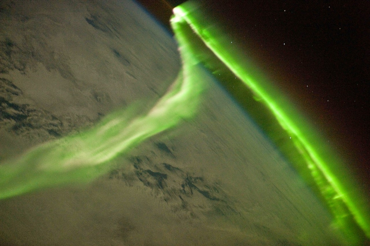
This one and the one above are taken from a satellite camera, in a circular orbit around the earth. 


Monday, December 1, 2014

Glaciers of Iceland

   The glaciers and ice caps of Iceland cover 11.1% of the land area of the country (about 11,400 km² out of the total area of 103,125 km²) and have a considerable impact on its landscape and meteorology. 


An ice cap is a mass of glacial ice that covers less than 50,000 km² of land area covering a highland area and they feed outlet glaciers. Glaciers are also contributing to the Icelandic economy, with tourists flocking to the country to see glaciers on snowmobiles and on glacier hiking tours.


Here on these photos you can see how the ice crawls after the earth carving the most amazing landscape. 


Many Icelandic  ice caps and glaciers lie above volcanoes, such as Grímsvötn and Bárðarbunga, which lie under the largest ice cap, Vatnajökull. The caldera of Grímsvötn is 100 km² in area, and Bárðarbunga is 60 km²


When volcanic activity occurs under the glacier, the resulting meltwater can lead to a sudden glacial lake outburst flood, known in Icelandic as jökulhlaup, but jökulhlaups are most often caused by accumulation of meltwater due to geothermal activity underneath the glacier. Such jökulhlaups have occasionally triggered volcanic eruptions through the sudden release of pressure.


Iceland is losing ice due to climate change. Okjökull glacier in Borgarfjörður, West Iceland, has lost its glacier title and is now simply known as “Ok”. In order to fit the criteria glaciers need to be thick enough to sink and move under their own weight, which Ok is not. Ok is the first Icelandic glacier to loses its title.


It can be a real fascinating thing to see icebergs big as houses break off from the giant glaciers splashing into the glacier lagoon, its quite a unique experience. 


Welcome to the land of ice and snow 


Sunday, November 9, 2014

Vestmannaeyjar


The Westman Islands 

are a group of 15-18 islands, depending on how they are classed, and about 30 skerries sand rock pillars, located off the mainland’s south coast. The islands were formed by submarine volcanic eruptions along a 30-km long fissure lying southwest to northeast. The largest island is Heimaey, 13.4 km2.Most of the islands have steep sea cliffs, and are well vegetated. Bird hunting and egg collecting are traditional to the islanders’ culture.


                                             A Norse timber church


A gift from the Norwegians to commemorate 1000 years since Christianity was accepted in Iceland, was consecrated on Heimaey. The only church of its type in Iceland, it has been situated at the Skans area where a stone wall, built after theTurkish invasion in 1627 occurred, has been rebuilt. Population 4,416. 


                                                         The Community             


Hunting and fishing are the traditional mainstays of the island economy. Rich fishing grounds surround the islands. 


For many years Heimaey was one of Iceland´s largest fishing stations. During the main season, people, from all places and walks of life, flocked here to work long hours and earn money. The population of the town trebled and the number of boats multiplied. Today, ships are larger and more technologically advanced, production has moved from landbased freezing plants to factory ships and consequently the hustle and bustle of the main season is much a thing of the past.


                                                               Surtsey 

On the morning of 14th November, 1963, crew aboard Ísleifur II saw a column of black dust rising from the sea, south-west of Heimaey. An eruption had begun on the seabed which was to last almost four years. By the second day of the eruption the island, Surtsey, was already 10 metres high. When the eruption ended, on 5th June, 1967, the island covered 2,8 square km and reached a height of 170m. 

Surtsey is protected by law and Icelandic scientists continue to document the colonization of the island by plant and bird life.

The Eruption on Heimaey, 1973
The eruption on Heimay began on 23rd January, 1973, just before two o´clock in the morning. A fissure opened on the eastern side of the island, only 300-400 metres from Kirkjubæir, the most easterly houses in the town. 

The inhabitants of Heimaey were woken by the police and firebrigade as they drove around, raising the alarm with their sirens. People streamed down to the docks. Fortunately the weather had been stormy the day before and most of the island´s fleet of 60-70 fishing boats had stayed in harbour. The boats ferried the town´s people to safety in Þórlákshöfn. In March, moltern lava threatened to close the harbour approaches. In a desperate attempt to stop the flow, seawater was pumped on to the lava. 

This method proved very effective. Today the harbour is considered to be even better than before. The eruption ended on 3rd July, 1973. In six months a new volcano, 225m high, had appeared on the island and a new lava field lay to the east and covered 3.3 square km. Around 360 houses 
had been buried and many others 
badly damaged. 
Before the eruption 
5300 people lived on Heimaey, 2000 of these moved back 
immediately after the eruption ended. 
Slowly but surely more families returned and began to rebuild 
their community.

The Turkish Invasion

Probably the most tragic incident to take place on the island was the Algerian pirate raid in July of 1627. The pirates landed on Heimaey and proceeded to pillage and plunder, burning farms, houses and the church, and killing or kidnapping 242 of the island’s 500 inhabitants.

Those who were kidnapped were transported to the slave market in Algeria and most of them were never able to return to Iceland. Some died along the way; others could not adjust to the conditions of slavery, and a few eventually started new lives in the world of their captives. The inhabitants who escaped the pirates during the attack had hidden in caves and at cliffs along the ocean. Many place names on the island are reminiscent of this terrifying attack, such as Pirates’ Bay and Hundred 
Man Cave. 

It is said that 100 people 
hid here, though they 
were eventually 
discovered by the pirates
 because of a dog that had been waiting outside the cave. 

One woman
Guðríður Símonardóttir, 
sometimes called Turkish Gudda from Stakkagerði 
in Vestmannaeyjar is 
probably the most 
famous of the captives. 
She was one of the few 
who was released from c
aptivity and returned to 
Iceland, 
though she never
returned to Vestmannaeyjar.She married the poet and author of the Icelandic psalms, Hallgrímur Pétursson who served as a priest in Suðurnes and Hvalfjörður. 


Here are more photo's taken in Vestmannaeyjar.


A photo of Vestmannaeyjar town


Here is where people come to party every year in a festival called Þjóðhátíð in this place called the Dalurinn


Saturday, November 1, 2014

Dynjandi

Iceland

Vestfyrðir, westfjords

The impressive Dynjandi 
waterfall plunges over a 100m-high clifftop into the fjord at Dynjandisvogur inlet, forming a triangular cascade roughly 30m wide at its top spreading to over 60m at its bottom. 


Below the main waterfall a series of five smaller chutes carry the waters of the Dynjandisá to the sea. Lit by the low sun, it’s an incredibly pretty place to camp out on a summer night, though the waterfall is famously noisy, 


Dynjandi means “the thundering one”.


All -distance buses make a ten-minute stop at Dynjandi; and with your own transport, it’s possible to reach the head of the falls.


Dynjandi is located
twenty kilometres east of Hrafnseyri, at the point where
Route 60 weaves around the 
northeastern corner of 
Arnarfjörður, if you should be located in the area Dynjandi is definitely a place you don't 
want to miss.   


Tuesday, October 28, 2014

Hljóðaklettar

North Iceland 
''The Echo Rocks''
Are in N-Iceland just south of Ásbyrgi in the Jökulsárgljúfur National Park.
When coming down the road leading to Hljóðaklettar a whole walley of extraordinary rock formation opens up.


These extraordinary rock formations, many of them standing in the middle of Jökulsá river (Jökulsá á Fjöllum) are the remains of volcanoes which have been eroded for centuries after centuries by the strong currents and floods of Jökulsá.


Jökulsá is the river coming from Dettifoss and Vatnajökull glacier, leaving only these extraordinary volcanic plugs behind.

Amazing close up of the rocks


Geysir, Iceland

Here you have a photo of Geysir in full action, it only takes a moment but when it happens it's truly an incredible force in display.
Geysir, Iceland

Geysir is a geyser in southwestern Iceland. It was the first geyser described in a printed source and the first known to modern Europeans.

The English word geyser (a periodically spouting hot spring) derives from Geysir.The name geysir itself is derived from the Icelandic verb geysa(to gush) the verb from old Norse.

Geysir lies in Haukadalur valley on the of Laugarfjall hill.

Eruption in Geysir can hurl boiling water up to 70 meters in the air. However eruptions may be infrequent.  


Monday, October 27, 2014

Here is a little bit clearer photo of Súlur.

Súlur

They call it Súlur, as you drive past this vast rocky mountain in the South West of  the town Akureyri in Iceland you see the huge head off the mountain in all its glory. Súlur rising some 1213 meters is popular for hiking tours.


Popular Posts